

Legal Services
For over 20 years, Siteline has offered a portfolio of services for clients that span market sectors and include a range of legal services that call for specialist expertise and industry knowledge.
Land Registry Compliance
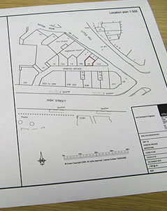
Compliance with Land Registry procedures and documentation is critical to any property development project. Siteline produces accurate scaled plans that meet all HM Land Registry guidelines and are intrinsic to the conveyancing and legal processes associated with commercial and residential property acquisition, development and sale.
Attention to detail is paramount when preparing lease plans, transfer plans, conveyance plans or determined boundary plans and our experience ensures complete accuracy and strict accordance with the Land Registration Act 2002.
Boundaries
If you simply want accurate, unequivocal answers on boundary issues, talk to Siteline about a boundary survey. We have extensive experience in undertaking boundary surveys for conveyance purposes (sale and acquisition) and in the reconciliation of Land Registry and other legal plans.
A great property misconception is that Land Registry hold the precise position of the boundaries to all registered land – they do not. They maintain a comprehensive register of land which includes a title plan that shows the general position of boundaries based on small scale Ordnance Survey mapping. The non-precise nature of most boundary information can often lead to disagreement or even litigation between adjacent landowners; it’s therefore essential to get early expert advice with regard to any boundary matter.
Lease Plans
Lease plans are accurate drawings that identify a leasehold demise within a property and which must comply with HM Land Registry regulations, in particular the Land Registration Act 2002. Siteline produces lease plans based on accurate measured building surveys.
Rights of Light
As developers strive to achieve higher density developments, particularly in the urban environment, there has been an increase in rights of light issues and litigation. Whilst most designers and architects are familiar with the requirements for daylight and sunlight analysis as part of the planning process, a number of recent, high profile court cases suggest developers ignore rights to light at their peril.
It is increasingly becoming standard practice for the rights of light assessment to be carried out at a very early stage of design. Considerable savings can be made by including the additional data collection as part of the initial topographical or measured building survey. Our laser scanner is invaluable for collecting accurate data on surrounding buildings and the resulting 3D computer models can be used directly in proprietry software to determine the affect that the proposed design will have on neighbouring properties. Siteline have the equipment and the expertise to fully support your rights of light assessment.
Licensing Act Plans
If you’re considering a licensing application, you’ll need the support of Siteline’s professionals who undertake surveys and produce plans in accordance with the Licensing Reform Act 2003.
We carry out surveys of and for licensed premises, producing accurate, dimensional plans that comply with the Act, showing site boundaries, fixed structures, safety and access points and fire escape routes etc.
EPCs
Every non-residential building that is constructed, marketed for sale or to let is required to have an Energy Performance Certificate (EPC) that measures and presents its energy efficiency and carbon emissions.
Siteline uses the industry’s most advanced software to produce the precise zoning information that’s needed to support the efficiency and emissions calculations required for the EPC document.


